 Glenholm Wildlife
Project
Glenholm Wildlife
Project
Glenholm Wildlife
Project
![]()
 The
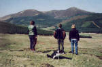
Glenholm Wildlife Project is based at Cardon Farm, an upland sheep farm of some
1,000 acres. Four way-marked paths varying from a two kilometre riverside walk
to a more challenging ten kilometre walk around the hills that mark the farm
boundary help you to explore and enjoy this area.
The
Glenholm Wildlife Project is based at Cardon Farm, an upland sheep farm of some
1,000 acres. Four way-marked paths varying from a two kilometre riverside walk
to a more challenging ten kilometre walk around the hills that mark the farm
boundary help you to explore and enjoy this area.
As part of the project stiles have been erected to make it easier to follow these routes, while numbers have been fastened to the way mark posts and these are referred to in booklets produced for sale at the Glenholm Gift Shop to interpret the glen in terms of farming, wildlife and archaeology.
All walks begin at the Glenholm Centre. Please read our Farm Etiquette guidelines and check in at the Centre to collect a free map for the route you wish to follow before you set out for your walk. A version of each map is also available by clicking on the icon alongside each route described below. Also check the notice board outside the Glenholm Centre for any details of any current farm safety issues.
Approximate Length: 2 Kms
Terrain: Moderately easy - no steep slopes; some small ditches; may be wet in some areas; no stiles; usually suitable for walkers with dogs.
 Brief Description: This is the most
gentle of the four walks, starting along the glen road which runs parallel to
the Holms Water river. The route then crosses some rough but level ground to the
river side, and then hugs the east bank of the Holms Water back to the Holms
Water river, before returning to the road and back to the Glenholm Centre.
Brief Description: This is the most
gentle of the four walks, starting along the glen road which runs parallel to
the Holms Water river. The route then crosses some rough but level ground to the
river side, and then hugs the east bank of the Holms Water back to the Holms
Water river, before returning to the road and back to the Glenholm Centre.
Approximate Length: 3 Kms
Terrain: Moderate - one steepish slope up to the Fort; may be wet in some areas; two stiles, both alongside gates so usually suitable for walkers with dogs (please read our section on Farm Etiquette before setting out).
Brief Description: This starts with a gentle walk up the glen road. Just past the pond and hide the route turns left and follows a side stream up a gully into the hills. At certain times this part of the walk can be quite wet. Nearly a kilometre up this gully the route turns sharply left and up a well worn but steep path to the Iron Age Fort. From the fort there are great views of the glen. From the fort the route returns down to the road following the outside of a field where there are usually sheep, and past the rookery. From the road the route takes you back the short distance to the Glenholm Centre.
Approximate Length: 7 Kms
 Terrain:
Moderate - one steepish slope up to the Fort; may be wet in some areas; one
stile, alongside a gate so usually suitable for walkers with dogs (please read
our section on Farm Etiquette before setting out); look out for cattle in the
field at the end of the walk (the School Brae).
Terrain:
Moderate - one steepish slope up to the Fort; may be wet in some areas; one
stile, alongside a gate so usually suitable for walkers with dogs (please read
our section on Farm Etiquette before setting out); look out for cattle in the
field at the end of the walk (the School Brae).
Brief Description: As far as the fort this walk follows the same route as the Fort Walk. Having reached the fort the path climbs across moorland all the way up to the boundary fence. At the fence you may choose between turning right and climbing the last 100m up to the summit of Blakehope and turning left and following the farm's boundary fence (march).
The walk up to Blakehope uses a stile to cross a fence (there is no gate) and then traverses some very old and tangled heather, but the views at the top, especially looking down into the Tweed valley, are well worth the effort. To carry on the walk you need to retrace your steps back through the heather and then follow the boundary fence.
The fence takes you all the way down to the far eastern corner of the farm, and then back along a fence that runs parallel to but overlooking the Holms Water river. On reaching the end of this fence next to a large shelter belt, the path turns right through a gate and through the School Brae down to the Glenholm Centre.
Approximate Length: 10 Kms
Terrain: Moderate to Difficult - one steep downslope at Preston Hill on the first half of the walk; one steepish slope up to the Fort; may be wet in some areas; the first half of the walk can be particularly wet in some areas; this first half is also less suitable for walkers with dogs as two stiles do not have adjacent gates and many of the fields in this area are used for cattle; you should also look out for cattle in the field at the end of the walk (the School Brae).
Brief Description: As far as possible this walk follows the farm boundary (the march). The walk begins by crossing the Holms Water river, passing by the farm steading and up the road onto to the north-west. On reaching the white building at the top of the hill (Cardon House) the route heads through fields directly up the hill as far as the farm boundary.
On reaching the boundary fence a short detour takes you to another of the farm's Iron Age forts. The route then turns left, following the boundary with forestry on your right and fine views of the glen to your left. After about a kilometre and a half the boundary fence turns sharply left and goes steeply downhill to the valley floor.
At the bottom of this hill the route turns left, crosses a stile and follows the north-west bank of the Holms Water as far as the Glenhighton road. At the road the route turns left, crosses the Holms Water and then follows the road back along the glen almost as far as the pond and hide. At this point you can choose between carrying on down the road back to the Glenholm Centre and following the Blakehope route which covers the south-east half of the farm boundary.
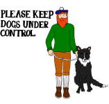 When walking in Glenholm please observe the
following guidelines:
When walking in Glenholm please observe the
following guidelines:
Leave gates as you find them
Keep dogs on leads when near livestock
Do not walk near sheep with dogs during March, April and May when lambing is in progress.
Never take dogs into fields containing cows
Avoid fields that contain cows with young calves
Avoid walking directly across cultivated fields
Take your litter home with you
Avoid picking any wild flowers
Keep clear of the farm steading and all farm machinery
Avoid walking through private gardens
Please note that visitors to Glenholm explore the area at their own risk. Where possible please follow the routes which have been waymarked for you and if you see anything that concerns you please take no direct action but notify the Glenholm Centre as soon as possible.

 © Glenholm Wildlife Project